The Ultimate One-Day Trip to 8 Waterfalls in Redding, California
Last Updated on March 25, 2025
Redding is one of my favorite cities to visit in California. The surrounding area offers a fantastic look into everything that makes the northern part of our state beautiful. From the frost-capped Mount Shasta to the misty forests and glittering rivers, there’s so much to see here. I call Redding “the waterfall capital” because waterfalls are an especially iconic part of this region. Did you know you can visit eight waterfalls in Redding, California, in just one day?!
Thanks to Visit Redding for sponsoring this trip!
The last time I talked about Redding, I shared many great waterfalls and landmarks you could see here. This list will go through some new, underrated waterfalls along the loop just northeast of the main city. If you’re interested in seeing other great things Redding offers, check out my blog post on Redding and Shasta Cascade!
Loop through 8 Waterfalls in Redding, California
The loop starts and ends in Redding, circling around the northern forest and mountain area via Highways 299, 89, and 5. Looking at the map below, we’ll follow the road counter-clockwise along the loop.

Going to the waterfalls in Redding, California is actually quite easy. Most of the trails leading to them are round-trips near the main highway. In total, the entire loop can be done in a 5.5-hour road trip–perfect for a day trip or a quick view of the natural scenery.
If you’re heading out in the spring or winter seasons, be sure to check for weather conditions. There’s often snowfall even late into April around Mount Shasta!
I took some shots of the gorgeous views in this loop. If you’re interested in seeing a preview of what’s to come, you can find them on my reel!

Potem Falls
The first stop along the loop is Potem Falls, a breathtaking waterfall that takes less than 20 minutes to hike. The trail toward it is an easy 0.6-mile hike into lush forests, where you can see and hear the waterfall’s roar from below.
Potem Falls stands over 69 feet tall and into the Pit River branch of Lake Shasta. The stream of water here pours out of a narrow passage at the top, letting the water spread out in a wide curve below. The small pool below the falls serves as a great swimming hole in the summer.

View of Potem Falls from above on the trail
In spring, however, the waterfall’s flow is incredibly strong and makes for a better photo spot than a swimming attraction.
Once you’re finished soaking your toes and admiring Potem Falls, you can head back on the road and drive straight until Four Corners. Here, you’ll take the intersection into Highway 89, riding up to our next waterfalls.

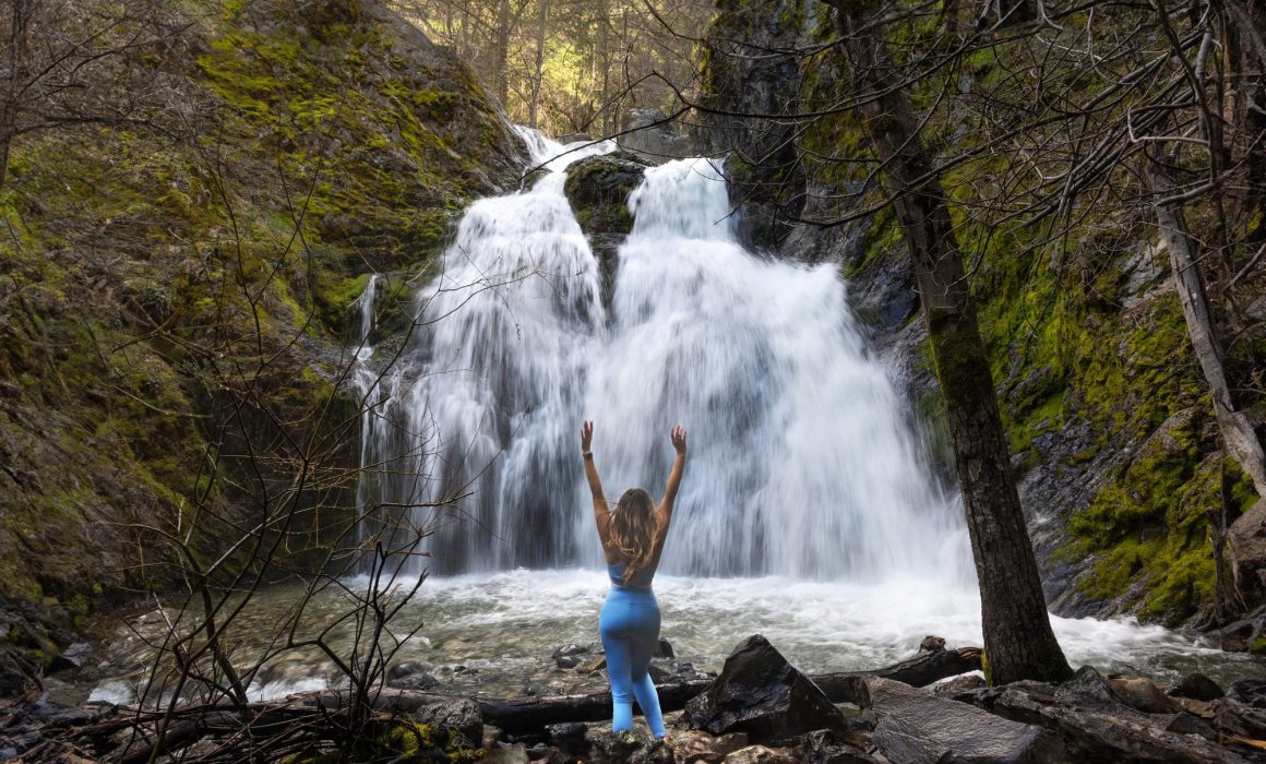
Our next stop is Burney Falls, undoubtedly one of the best waterfalls in California. Although its main trail is closed for renovations during the spring and summer seasons of 2024, you can still see the falls. Other trails in the park remain open for access. For more information about the reconstruction, visit the Shasta County website.
These falls stand a monumental 129 feet tall, flooding over the rivers below. There are numerous streams of water falling over the rocky walls. The main highlight, however, is the two giant streams rushing out from the sides of a jut-out cliffside, pouring down like tears.

Burney Falls
McCloud Falls
I’ve talked about these falls before when discussing the best waterfalls in California. Many of the waterfalls in Redding, California ended up getting into that list, but these falls are especially notable. Even now, they’re still some of the most captivating waterfalls the Golden State offers, and you can see them all in just a few hours!

McCloud Lower Falls
The waterfalls are split into three–the Lower, Middle, and Upper Falls. McCloud Lower Falls is the easiest to get to since it’s only a 0.2-mile walk to the falls. You can even enjoy the waterfall from a glance over the viewpoint near the parking lot.
Lower McCloud is the busiest out of the three McClouds. It’s smaller than the other two but makes up for it with a cool pool and rock formations to sit along. Due to its size, this waterfall is quite pleasant and amiable to idle around and take pictures with.

McCloud Middle Falls
The McClouds Middle Falls are my favorite out of the three. They’re a little further than the rest, being an easy-to-moderate 0.8-mile hike away, and they’re absolutely stunning. The falls here stretch over a rocky cliffside in a smooth, steady motion.

McCloud Middle Falls
The trails around these falls give a wondrous view of the waterfalls, framed behind the canopy of trees. The main Middle Falls trail zigzags along dirt roads with rustic fences looking over the falls. It’s gorgeous any time of the year, but I especially like the rush of energy it has during spring.
If you’re taking the trail to Middle Falls, be sure to check the nearby signs for directions. The bigger McCloud hiking trailhead starts near the same parking lot, and it’s easy to mix the two up. When in doubt, you can look at the AllTrails app for more detailed directions to the trail.
McCloud Upper Falls
The walk to these falls only takes 6 minutes of walking down a 0.3-mile paved road. It has a convenient day-use area nearby, and viewpoints to admire the falls from. Compared to the other sections, the upper falls are much taller, standing at an impressive 25 feet.
The cliffsides are rugged and blooming with trees, guiding the rushing water down into the river stream below. Unlike the Lower Falls, you can’t get too close to these waterfalls, but they’re still majestic to look at from above.

McCloud Upper Falls
These sections are bunched together closely, and you can drive to each one to save time. If you have more than a day to visit Redding and Shasta Cascade, you can try out the McCloud Waterfalls Trail! It goes through all three waterfalls in around an hour and a half, and it’s an easy but fun hiking trail to walk with friends.
This mysterious waterfall is hidden among the remains of the Ney Springs Resort. After heading out from McCloud, you can continue through Highway 89 until you reach the intersection connecting Highway 5.
The trail to these falls is down south from WA Barr Road and then left on the Ney Spring Roads. The Google Maps directions here can sometimes lead you down the wrong path, so I’d recommend downloading the Alltrails map ahead of time. Once the Ney Spring Roads curves right, you can park your car here and start hiking up the trail.

Faery Falls
Faery Falls itself is a brilliant spectacle that you can walk up close to. The waters of the falls split in the middle because of a giant boulder, making a wing-like structure on the cliffside. It glitters white and gold in the springtime, filling the cool springs below.
You’ll likely find the debris and remnants of the old Ney Springs Resort around here, first built in the 1800s. There are some walls, ancient cisterns, and a few pipes used to transfer water from the springs to the people.
The waterfalls in Redding, California have always been lovely, but few hide such a strange and storied history around them. It seems like the springs and Faery Falls were quite popular, even in the distant past.
I’m always amazed by the diversity of sceneries in California. You might not expect it, but you can find a glimpse of Iceland or Oregon right here. Hedge Creek Falls is truly unique, allowing you to walk behind the falling water.
This waterfall is an easy 0.6-mile hike near the city of Dunsmuir. After driving south on Highway 5, you’ll find a parking space next to the road and a trail leading up to the falls themselves.

Hedge Creek Falls
As this is nearing the final stretch of the waterfalls in Redding, California loop, you can take some time to stand inside the cave and enjoy the views. The drive down after Hedge Creek is also incredibly romantic. Mount Shasta overlooks Highway 5, with Castle Dome and the craggy cliffsides following along.
Once you pass by all of those views, you’ll find yourself in our serene last waterfall over a bridge.
This one’s as sweet and simple as the name sounds.
SweetBriar Falls, just down the road from Castle Crags State Park, flows into a thin branch of the Sacramento River. You can take a detour from the highway onto SweetBriar Avenue, then park near the bridge leading to the waterfall’s main view. After this, you’ll head right to the charming SweetBriar Falls.

Long Exposure shot of Sweetbriar Falls from the bridge
There’s a quaint pedestrian bridge over this waterfall, and it’s the only way to admire SweetBriar from up close. The stream here flows calmly into the river, carried by an array of mossy boulders and tall evergreens. Here is how it looks from a long selfie stick:

Sweetbriar Falls – shot from Insta360 on a long selfie stick
These fairytale surroundings make for a perfect ending to our trip through 8 waterfalls in Redding, California.
Still, if you’re up for it and have the time, there’s one more waterfall to explore!
Bonus: Mossbrae Falls
Every time I talk about Redding, I somehow always bring up Mossbrae Falls. It’s hard not to! There aren’t many other places in California, or even the US, where you’ll find moss curtaining streaming water above.
It’s an awe-inspiring array of native flora dancing with the rivers and geography around it. The pool below is sometimes shallow enough that you can walk and stand on the stones just below the falls. There’s something so whimsical about the view here, making you feel transported to a completely different time and place.

Mossbrae Falls
Note: Mossbrae is technically within private property and thus is closed off to the public. There are still some risky trails leading over the nearby train tracks towards Mossbrae. However, I would recommend waiting for the county to announce an official path later in the future.
If a path does open up later on, you’ll find Mossbrae just behind Hedge Creek Falls. I imagine going from the cavernous Hedge Creek to the green Mossbrae would make a memorable trip!